
OpenSpace Creates Construction Reality Capture Platform with OpenSpace Air
[ad_1]

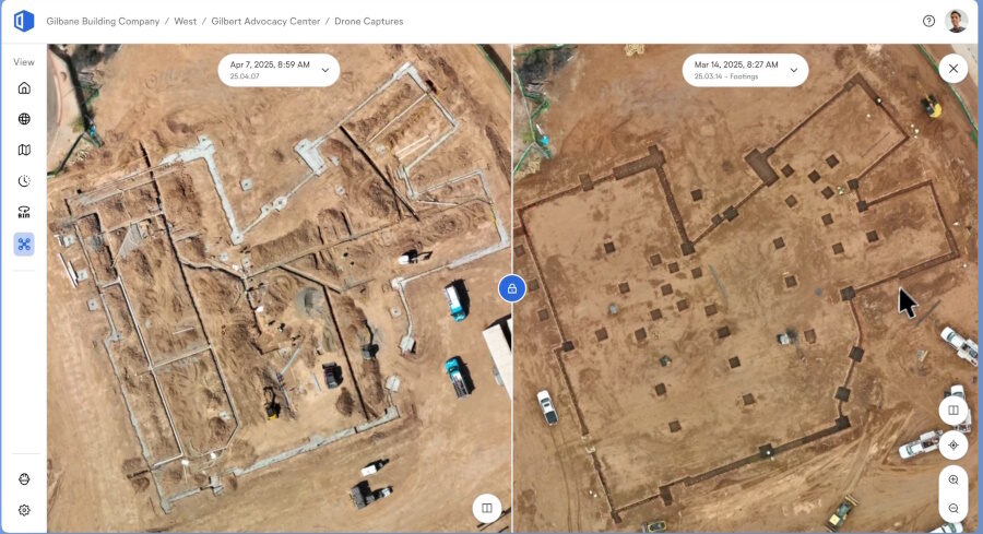
OpenSpace, a 360-degree reality capture and artificial intelligence-powered analytics platform for construction, on May 14 released OpenSpace Air, a cloud-based repository that enables building and construction teams to consolidate all reality capture data, including from drones, 360-degree cameras, mobile phones and laser scans, into a visual record,
OpenSpace Air is included with all existing OpenSpace subscriptions and is available immediately. Aerial data from drones has become a popular tool for capturing stages of project completion since 2010. These include the phases of pre-construction planning and estimation to site surveys, topographic mapping, marketing and even client communications. By pairing aerial imagery from drones with interior reality capture, OpenSpace Air is designed to help project managers and executives access that project data throughout its lifecycle.
“With the drone data integration from OpenSpace, we can now expand outside the four walls of a building to show things that we weren’t able to see before, from an extremely valuable perspective,” said Scott Wyatt, project executive at Gilbane Building Co. in a statement. “Overall, being able to identify items on the project earlier and create efficiencies in our platforms is a big win.”
OpenSpace Air leverages spatial AI technology to deliver insights from the project data captured on its platform. Upload and processing of up to 500 images can be completed in roughly four hours. The technology is drone-agnostic and compatible with any drone and flight planning app. The platform can process and give users access to orthomosaics, point clouds, 3D meshes and elevation models. Mobile photos and laser scans were already available in the OpenSpace platform. in addition to 360-degree images which can be knitted together.
The platform can also be used to overlay drawings directly onto a map for planning and verification. Users can compare multiple drone flights to track changes and progress over time. For mobile images and video, the platform is compatible with both iOS and Android, so field teams can interact with drone imagery on both.
“We developed OpenSpace Air to address a key challenge from our customers: centralizing all reality data in one place,” said Jeevan Kalanithi, CEO of OpenSpace. “OpenSpace Air gives construction executives the ability to track project progress more effectively, make quicker decisions and reduce tech stack complexity. With OpenSpace already used to capture more than 40 billion sq ft of projects, field teams can also quickly and easily work with drone imagery on a platform they know.”
DroneDeploy currently operates and maintains the largest cloud-based, drone-captured data platform for construction.
[ad_2]
Source link

Post a Comment
You must be logged in to post a comment.