Autodesk Updates Forma With Seamless GIS-BIM Workflow
[ad_1]

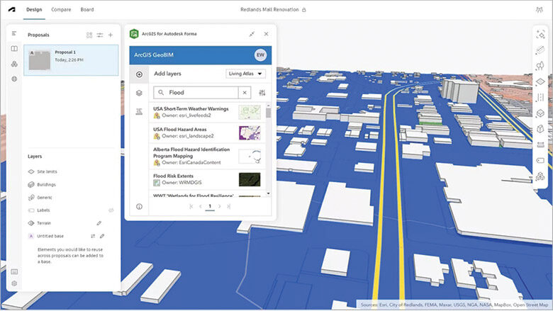
During the American Institute of Architects’ 2025 Conference held in Boston June 3, Autodesk released ArcGIS for Forma, a public beta for a cloud-based connection that links up Esri’s ArcGIS and Autodesk’s Forma design environment.
“What customers are able to do with this update is incorporate a wide array of contextual geographic data from ArcGIS, which includes buildings, zoning, roads, boundaries, imagery, a huge amount of data,” said Carl Christensen, vice president of product at Autodesk. Christensen is also the co-founder of start-up Spacemaker, whose software became the basis of Forma after Autodesk acquired the firm. “From a Forma perspective, that allows architects and planners to gather insights early in the design process. That’s been our mission for a long time. To set up your project in the best possible way.”
While the capabilities of Forma have focused on conceptual design in the first years of its development, Autodesk still wants to make it the design environment for architecture and engineering, moving data from one stage of design to the next.
Connecting ArcGIS to Forma has been something both Autodesk and GIS giant Esri have talked about as a goal of their ongoing strategic partnership. ArcGIS GeoBIM, an Esri product, was the first data environment that allowed movement of data across both systems and the visual display of directory trees to help simplify the process of getting data from ArcGIS to Revit or Civil3D. Reentering features from maps into parametric data has been a longtime pain point for engineers.
“Our augmented reality technology hinges on visualizations that function as counterparts to the physical world, so the seamless use of public and proprietary spatial data is critical for customers,” said Dana Chermesh-Reshef, founder and CEO of tech firm inCitu. Her company uses augmented reality to turn real estate and planning data into interactive, accessible experiences for project stakeholders, including developers, city governments, architects and engineers. “ArcGIS for Autodesk Forma’s interface is easy to use and responsive, while accessing data is intuitive for AECO professionals with even limited to no GIS experience.”
Forma has been connected to Autodesk Docs, the company’s cloud AEC and owner data repository since 2024, and this release expands that connection, bridging workflows from Forma to Autodesk Construction Cloud.
Docs users now can access the Forma board, which is an unlimited scrolling workspace. Forma is already available as a navigation module in ACC, and subscribers to Autodesk’s AEC Collection will soon be able to switch between ACC’s construction management tools and Forma’s design tools.
[ad_2]
Source link

Post a Comment
You must be logged in to post a comment.