
Insufficient Risk Mapping, Overdevelopment Cited in Texas Flood Tragedy
[ad_1]

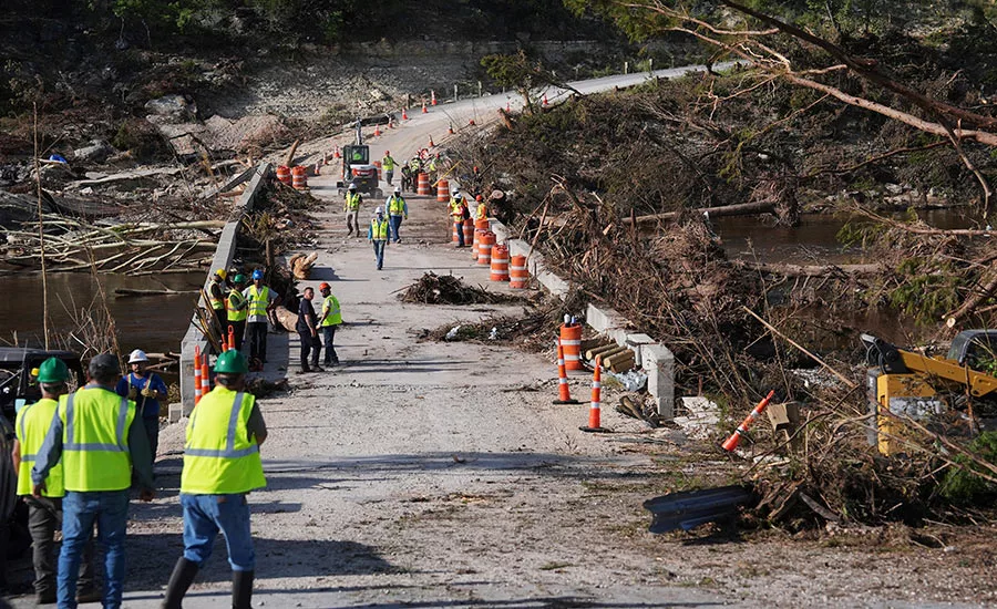
Overdevelopment in flood-prone areas and inadequate mapping from the Federal Emergency Management Agency likely contributed to the tragedy that unfolded in central Texas July 4, when sudden flooding of the Guadalupe River led to a death toll of 120 as of July 14, with many more still missing, according to sources familiar with the situation.
Adnan Rajib, an associate professor of engineering at the University of Texas, Arlington, said that while the river in the state’s Hill Country region has flooded seven times in the past 25 years, his team’s modelling suggests that decades of overdeveloped property near the river has left flood waters with nowhere to go during heavy precipitation events. “Had we left more room for the river, the July 4 flood would have risen more slowly and covered a smaller area,” he told ENR.
Camp Mystic, where many children and counselors—including the camp’s owner—were swept away, is located within that flooding corridor. FEMA added Camp Mystic to its 100-year flood hazard maps in 2011 but subsequently removed many campground structures from the maps at the request of camp owners, according to an Associated Press investigation. Inclusion in the maps limits future construction and requires higher premiums on flood insurance.
Moreover, Texas has lagged behind some states in adopting proactive emergency mitigation plans. This summer, the Texas legislature nearly passed a measure that would have installed early alert weather-warning sirens, but ultimately rejected it, deeming it too costly to implement. The Texas Tribune reported in June that more than hundred out of the 254 counties in the state lack an emergency mitigation plan for natural disasters at all.
Jeremy Porter, head of climate implications research at First Street, which tracks sea-level rise among other hazards and also creates its own maps using data based on 100- and 500-year floods, added that while FEMA does map the probability of river flooding, it does not include rapid-precipitation events and smaller waterways that can contribute to floodwater totals. “If you don’t map the small waterways, like creeks, tributaries and streams nor [rapid precipitation], you’re not actually going to be able to map the velocity accurately in terms of how this is a really intense rainfall event,” he said.
FEMA’s models, based on historic patterns are “really good,” Porter noted, but they don’t “take into account precipitation or adjustments we’ve seen in rainfall rates and intensities due to climate change.” It will take an act of Congress to allow the agency to change the way it puts together its flood-risk maps, Porter said.
Implementing Changes
FEMA itself has been under significant scrutiny in Washington, with President Donald Trump seeking to eliminate it. A national FEMA Review Council that was established this year to provide recommendations for the agency’s future course held its second meeting July 9 in Washington, D.C. “I need you to reimagine this agency,” said U.S. Dept. of Homeland Security Secretary Kristi Noem, who co-chairs the council with Defense Secretary Pete Hegseth.
The council also includes 11 other members—a current FEMA regional director, three current or former state governors, other state and municipal representatives, the Republican National Committee chairman and an insurer CEO.
Noem said states should manage their own emergencies, with any successor federal agency tasked with a supporting financial role—largely through block grants only. “Our goal is that states should manage their emergencies, and we come in to support them, and we’re there in a time of financial crisis,” she said.
But the Union of Concerned Scientists suggested in a statement that the council could simply be a “farce” created to further dismantle FEMA—thus hampering “the nation’s ability to prepare for, respond to and recover from extreme weather and climate disasters.”
Zoe Middleton, group associate director of just climate resilience, said disaster recovery is expensive, and, with a few exceptions, most states don’t have resources to provide emergency response and recovery over the long haul.
“We have to ask what is the financial impact of [removing FEMA] responsibility but not funding and supporting states to respond to disaster,” she told ENR. “I worry there’s a real risk of favoritism among states based on their political relationship with the Trump administration.”
Bipartisan Support for Reform
Despite concerns about efforts to weaken or eliminate FEMA, lawmakers from both parties have called for significant agency reform.
“It costs a tremendous amount of money for disaster recovery efforts to come out of FEMA,” said First Street’s Porter. “The [National Flood Insurance Program] hasn’t made money really since its inception in the early 1970s,” he added. “If you were going to be critical of FEMA and the [flood insurance program], it probably wouldn’t be that hard to find inefficiencies in spending, management and relate that to just the huge budget that goes into things like disaster recovery.”
Porter stressed the implications of states’ disparate levels of ability to both respond and rebuild. Texas can better handle its own disaster response than North Carolina based simply on tax base, but both states might request the same amount of federal funding and support, he said.
Kevin Guthrie, executive director of Florida’s Division of Emergency Management, a council member who attended the July 9 meeting, said his state has invested heavily in setting up emergency response and recovery systems as well as investing in disaster-related technologies. Florida has adopted one of the strongest building codes in the country, he claimed. “We invest in that. We believe in it. We can take you up and down our beaches, up and down our state, where we show houses that are still unaffected [by storms].” The state also invested millions in generative AI technology for auditing records, he said.
University of Texas engineer Rajib points to the Texas Integrated Flooding Framework and regional flood planning groups that have linked tech companies, data providers and engineering firms with FEMA to modernize flood maps.
But he adds that FEMA needs an upgrade. “For too long, our focus has been on mapping flood zones based on probability: areas that might flood once in a century. We now need to turn those abstract maps into clear, location-specific risk information that people can act on,” he said.
Rajib added that “Equally important, we must track how risk grows over time by mapping human encroachment within floodplains—showing where rising risk will not only warn residents but also will guide smarter rebuilding decisions.”
The FEMA Review Council plans to release recommendations to revamp the agency in November.
[ad_2]
Source link


Post a Comment
You must be logged in to post a comment.